Monday, October 31, 2011

The Southern Cascades


The mist swirled around as we drove into Mt St Helen's. We laughed when we stopped at a pull out and all we could see was mist then while we sat having a cup of tea a gentle breeze began to lift the clouds and we got a fleeting view of the valley below before the cloud covered it up again.

Windy ridge Road, Mt St Helen's

The devastation from the eruption was everywhere from the thousands of dead trees fanning out from the blast zone to the pumice and volcanic rock covering the embankment beside the road as we made our way up to Windy Ridge.


Erosion along Windy Ridge Road

Still in the process of recovering

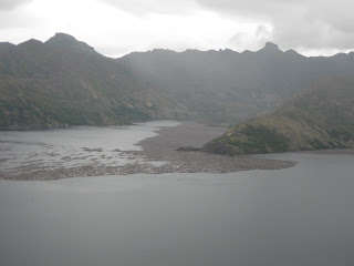
We stopped at another viewpoint overlooking Lake Helen saw hundreds of logs covering a large expanse of the lake.


Logs from the blast covering parts of Helen Lake 

At Windy Ridge the mist had lifted enough that we could now see the valley below, Lake Helen and the base of Mt St Helen's. This gave us hope that it was going to clear so we hiked up the stairs to a higher viewing area. But it wasn’t to be, the clouds descended once again and the chilly air had us scrambling back down to seek shelter in Dude.

We waited until late in the day for what was now total white out and around 5pm we headed back down the ridge and camped the night in a snow mobile park at its base.

The next day it was raining when we left and headed south enjoying the autumn colours of the forests on our way to Colombia River. We found a lovely campground across the road from “Beacon Rock”. The rain stopped long enough for us to climb Beacon Rock and then walk back to the campground through tall Douglas Firs, snow berry bushes, maple vines and ferns that covered every inch of the ground.

Beacon Rock, Columbia River

We called into the underwater viewing area at Bonneville Loch and Dam to watch the Salmon making their way upstream through the specially made fish ladders to spawn.

Afterwards we crossed the mighty Colombia River into Oregon and drove southwards through the fruit growing area. We called into one of the fruit stands and tasted the yummiest pears freshly picked from their orchard. In the distance Mt Hood was clocked in clouds and for the next few days the rainy cold weather accompanied us as we traveled through the thickly forested South Cascade Mountain Ranges. In the mountains we found lots of hot springs to soak in (clothing optional) that kept the cold from seeping into our bones.

Lush forests
After awhile the thick canopy of trees and continual rain had me pining for open spaces and it was with a sense of relief to arrive at Crater Lake. The road crews had just finished clearing snow from the roads from a storm earlier in the week. The contrast of snow against the deep blue water was beautiful and as we explored various viewpoints the clouds gave way to blue sky.

Crater Lake

During the day the Park Ranger opened up the Rim Road so we got to drive all the way around and we made the most of the sun coming out and hiked down to the water along the way.

A mixed weather day at Crater Lake

Mist covering the Rim Road
We had arrived back in California and conscious that our Road Trip was coming to an end and lots of places to explore on our way back to Pleasanton we wasted no time in making our way to Lava Beds NP.

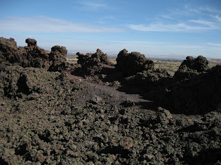
Lava flows at Lava Beds NP

We stopped on the way in and watched as the fog lifted revealing fields of lava flows and native bushes and a strong aroma of sage bushes filled the crisp morning air.

Mist clearing on our drive into Lava Beds NP

It was an interesting place to explore and we had lots of fun descending into the many lava flows and caves that covered the area. 

Exploring lava flow tunnels

More exploring of the tunnels
We inquired about a forest road that would take us directly south instead of having to backtrack. The lady in the Visitors Centre exclaimed that road was full of pot holes and not a good  road to be driving on. A day later when we hiked up to a fire lookout and got talking to the ranger manning the tower he advised the forest Road we inquired about would be just fine if we took it slow and advised he uses it to commute to work.

Hiking through Lava Beds

Our drove south on the pot holed part dirt road turned out to be a nice drive through the forest. We arrived at Medicine Lake and found a lovely spot overlooking the water. We promptly got Aqua Dude out and went for a paddle. 

Paddling Medicine Lake

To our delight as we paddled to the other side we saw a Bald Eagle sitting in the upper branches of a dead tree and paddled over to take some photos. While circumnavigating the lake we came across some deer stopping for a drink at the water’s edge.


Our sighting of a Bald Eagle

With the weather improving we stayed a couple of nights enjoying the tranquil scenery and taking walks along the water’s edge where every step had tiny sized frogs scurrying out of our way.

It was time to continue southwards to Mt Shasta and on our arrival it only took a few minutes to realize we were out of place in this wacky community. It seemed we had entered the twilight zone and the Capital City for crystal rock enthusiasts. On our drive to a campsite in the mountains we encountered the Alien believers. One believer was wearing an animal vest and both were adorned with feather earrings and bear necklaces. They exuberantly regaled us with their belief of the alien’s landing circle “man nothing grows their and did you see the strange twisted trees”.

Twisted trees around a circle....

Their happy enthusiastic energy was infectious and we smiled at each other as they drove off in their 70’s type RV amused at how it was clearing the precariously rocky road….maybe they had some help from the aliens?

Mt Shasta

There's got to be snow here somewhere

We've just been up there..

We drove into the township and sought out a Coffee House with free Internet. Sitting down to enjoy my coffee and update my Blog I was immediately entertained by a beanie clad, curly haired man who was busy chatting away as he walked around the coffee shop examining the walls. He had white headphones in his ears and held an antenna in his hand up to his face and by all accounts was very knowledgeable on other realms.

A realm of possibilities here....

We did some hikes and eventually came across the alien landing area and other interesting characters practicing yoga. One in particular for some time I thought was an odd looking tree stump but ended up being a shirtless, tight wearing yoga guru in a head stand pose.

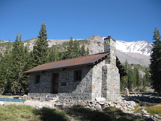
Sierra Club hut at Horse Camp

This truly was an inspiriting place and fitting that our journey had come full circle.

Celebrating completing our journey

I was sad our journey was complete but I was also excited that we were returning to Australia……where our new journey would begin.


Sunday, October 9, 2011

Olympic NP


My gloom soon lifted when we set out on a few day hikes from our camp ground. There were lots of interesting activities to do here in the North Cascades from exploring creeks along Ross Lake by canoe to hiking Desolation Peak. So with too much to choose from and thoughts of our time slipping away we decided to keep on driving westwards to the coast.

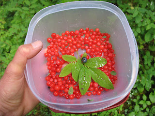
We arrived at Whidbey Island and drove south to Deception Pass State Park for the night and stayed at the campground located just below Deception Bridge. I was beside myself with excitement because the campground was full of ripe blackberries and western red huckleberries, so as soon as Dude was parked I headed out with my container to pick as many as I could for our breakfast.


Afterwards we walked along the beach where I had a wonderful time fossicking for pebbles. Although there had been a few showers during the day and it was cold enough to be rugged up in jeans and fleece jackets we still went in for a dip. The water took my breath away and I was surprised when I suddenly realised I was now in salt water. We dried off, pink and tingling with cold, then sat for a while to listen to the gurgling of waves as they were sucked back through the pebbles out to sea. When we arrived back at Dude I was in for another surprise because John had turned on the hot water so we could have a shower.

Deception Pass
It was a lovely clear day when we drove to Oak Harbour in Coupeville. While we waited for the Port Townsend car ferry to arrive we made a cuppa tea and walked over to the waters edge. It was a smooth 30 minute ferry ride which we spent on deck watching the beautiful clear blue water beneath us.

We walked around Port Townsend and enjoyed it's charm but we were disappointed at not finding a place to buy fish and chips. So with plans to catch a ferry into Seattle the next day we drove down to Bremerton to reconnoiter parking for Dude. It turned out to be a nightmare driving Dude around the narrow streets and finding limited parking and road works in progress so with one look at each other we decided to high tailed it back out to the peace and quiet.

We camped that night in Kitsap Memorial State campground and that afternoon I had a great time harvesting the fresh berries from the many bushes around the campground….it was wonderful. Later that afternoon we walked down to the pebbled beach and watched the sun set behind the mountains.


The next day we woke to a nice sunny day and drove back northwards to Port Angeles. After a quick look around the town we drove up a narrow winding road to Hurricane Ridge skirting past some deer darting across the road on the way.

Hurricane Ridge


The sunshine was too good to pass up so we spent the rest of the day hiking to the top of the Ridge. We got views of the Strait of Juan De Fuca, Vancouver Island and Mt Baker to the north and snow covered Mt Olympus and the Olympic Mountains to the south. Hiking back down we saw our first grouse camouflaged in amongst the grasses.

Our first Grouse sighting

Back in town we called into a small establishment called Colonel Hudson’s Famous Kitchen to accommodate John’s hankering for fish and chips. So with the aroma spurring us on we drove 3 miles along the “Ediz Hook” sand spit to find a nice spot by the ocean to enjoy our meal.


Beer, Fish & chips ....ahhhh
Our clam chowder entree was the best tasting we have had to date. The sunset over the ocean had us mesmerized so it was nearly dark when we set off for Elwha Valley where we arrived at the campground in the dark and went to sleep with the hum of the Elwha River.

On our way out of the Valley we stopped to look at Madison Falls before driving onto Lake Crescent where we then hiked out to Marymere falls. For most of the hike I was distracted by the hundreds of juicy red huckleberries and filled my water bottle cover to the brim with fresh berries.

Madison Falls

Later in the day we checked into the Sol Duc Campground and headed straight down to the Resort to soak in their hot springs. We walked back to Dude for an early dinner and then without hesitating went for another soak in the hot springs. By now it was raining but it didn’t matter.

Hot Springs

It was still raining the next morning when we drove up to Sol Duc Trailhead. We hiked in the rain to the falls and when it started to ease we continued on up to Deer Lake. It was very peaceful in amongst the lush forest on our leisurely hike back we stop frequently to pick some more berries.

Boardwalk at Deer Lake

Rain, what rain? 

Sol Duc Falls

Sol Duc Falls
We called into the Visitors Centre at Forks and enquired about the iconic coastal backpack from Rialto Beach to Ozette Lake but this late in the season the logistics of getting back to Rialto Beach was tricky so we decided we would do a day hike along the beach instead. It had taken us 5 months but here at Rialto Beach we had finally returned to the Pacific Coast.

After a feast of berries for breakfast we drove down to the beach. It was overcast but no rain. We followed the trail and as I crested the sand dune the wild coastal scene opened up before me. Grey coloured waves with foaming cream crests pounded the grey pebbly beach, logs surged in and out waiting to be tossed up high onto the dunes.

Rialto Beach
The tide on its way in had swallowed up the beach so we had to scramble over hundreds of logs marooned on the high water mark.  We continued like this until we reached the “Hole in the wall” a section passable only at low tide so the only option was to climb up a precarious trail over a ridge to the other side.


When we turned around it was easier going as the tide had gone out enough so we could walk on the pebbly sand and by the time we arrived back at the “Hole in the Wall” we could dash through it, if you timed it right.

Hole in the wall


By now I was feeling dog tired and the last mile took a lot of effort to cover and it made me realize that backpacking 15-20 miles a day would be hard work.

The next morning it was raining heavily as we drove down to the Hoh Rain Forest and made camp.

Raining as we started our Hoh Rainforest hike
We didn’t let the rain put us off our 12 mile return hike to the Happy Four shelter…….after all we were in a Rain Forest and true to its name the rain did not let up at all for the entire hike.


Happy Four shelter - Yes we are very happy

Still raining as we got back.


It was incredibly beautiful


Now with only a month remaining it was time to make a dash to the Southern Cascades.